LiDar Capable Drone from Carlson Software!

The American Made CAP50 UAV is ideally suited for Land Surveying, Construction, Engineering, Mining, Quarry and Mapping applications. With a payload capacity of up to 6lbs it offers multiple payload options for Photogrammetry, LiDAR, and Bathymetry.

The quadcopter features a Carbon Fiber frame and has 465KV motors rotating 18.5” carbon fiber propellers powered by a rechargeable 22.8V battery. Onboard is a RTK GNSS that utilizes a LiDAR range finder for altitude accuracy and vertical stability. The CAP50 can be programmed and controlled via an included flight controller with a touch screen.

Our DEMO unit is for SALE NOW! Ask for a Quote!


This product is currently out of stock and unavailable.

SKU: N/A Category:
Carlson Software logo

Description

KEY FEATURES
• Payload capacity up to 6lbs
• PPK & RTK for accuracy
• Tested in 50mph winds with max payload
• Terrain Follow
mission capability
• 22-minute flight time with 5lbs payload
• Compactible design for easy transport
• Full telemetry flightlog 
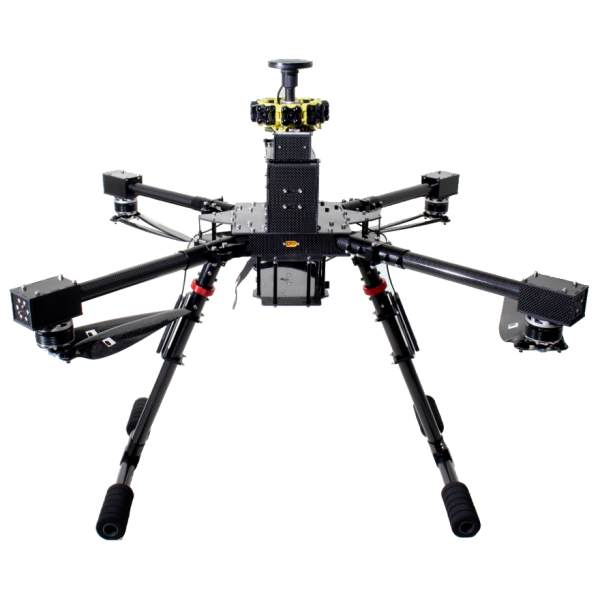
Propulsion
465KV motors combined with 18.5” carbon fiber propellers and the 22.8V 6S 25,000mAh battery for superior aerial performance. 

Position Stability and Accuracy
(GNSS) receiver compatible with Post Processed Kinematic (PPK) for best accuracy and Real Time Kinetics (RTK) GNSS systems. To ensure the drone has redundancy in the critical sensors needed for flight, Hawkeye integrates 2 magnetometers, 2 accelerometers, 2 gyro, and 2 barometers. A battery current and voltage sensor is used to track battery level. 

 Payload Configuration Options:

  • LiDAR (with 24MP Nadir camera)

Learn about Part 107 Certification here.

Click here to download the FAA Remote Pilot Study Guide

Click here for FAA Airman Knowledge Testing

Additional information

Options

UAV only, UAV w/Lidar & 24MP camera, add on Echo Sounder

Brand

Carlson Software

Carlson Software logo